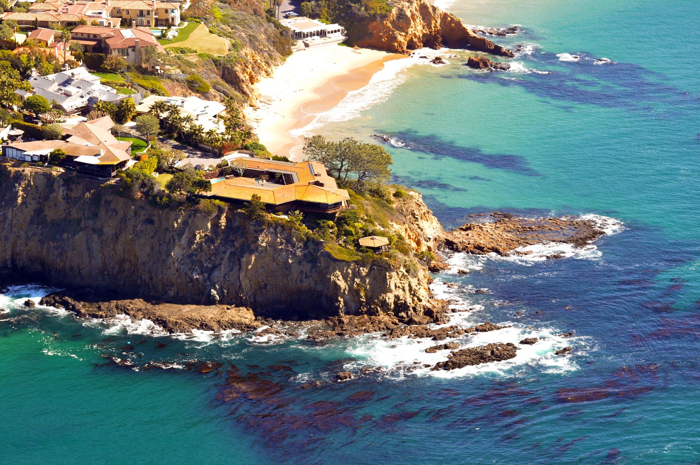
Laguna Beach neighborhood
Irvine Cove
Irvine Cove is a gated community of custom homes at the north end of Laguna Beach, on the ocean side of North Coast Highway.
Photo: Don Ramey Logan, CC BY-SA 3.0
What it’s like
Irvine Cove sits at the north end of Laguna Beach on the ocean side of North Coast Highway. A 2019 Coastal Commission staff report calls it a locked gate community in north Laguna Beach, and a 2002 report adds that the community predates the Coastal Act. Emerald Bay, an unincorporated community, divides Irvine Cove from the rest of the city’s coastline. Crystal Cove State Park, a 2,791-acre state park with 3.2 miles of beach, lies to the northwest.
A guardhouse stands at the entry from Coast Highway. Inside, a cove beach lies at the base of the bluffs. The Commission wrote in 2002 that the community’s position between the sea and the first public road keeps the public from reaching that beach. Land access to the beach is for residents and their guests. See the Irvine Cove beach page for the beach’s access rules.
realatrends.com describes custom homes with ocean views, including oceanfront and bluff-top estates, in styles from contemporary to traditional Mediterranean. It dates the community to the 1960s. Street names include Irvine Cove Way, Monaco Drive, Riviera Drive and Irvine Cove Court.
Offshore, the Laguna Beach State Marine Reserve begins at Abalone Point, the city’s northern limit. State rules bar fishing and any other take of marine life in the reserve.
The northernmost entry on the Coastal Commission’s Laguna Beach access list is Smithcliffs View Park, a public blufftop overlook about three-quarters of a mile from Irvine Cove Way in a straight line. Read about it on the Smithcliffs page. In 1982 the city circulated a draft environmental impact report for Irvine Cove North, a proposed tract of 48 custom homes on 25.8 acres bounded by the state park to the north and west. realatrends.com places Irvine Cove and Smithcliffs in North Laguna.
Getting around
By road, Irvine Cove Way is about 1.2 miles from Crescent Bay, 1.7 miles from Heisler Park and 2 miles from Main Beach. Irvine Spectrum is about 11.6 miles from Irvine Cove Way by road and John Wayne Airport about 11.7 miles. Coast Highway runs northwest toward Newport Beach and southeast through town.
The weekday Coastal Route trolley starts at the North Laguna/Heisler Park stop. Summer runs on its own schedule. Check the city’s stop map for the stop nearest your address, and see the getting around guide for the rest of the city’s options.
The Laguna Beach Unified School District runs the public schools. El Morro Elementary is at 8681 North Coast Highway, Top of the World Elementary at 21601 Treetop Lane, Thurston Middle School at 2100 Park Avenue and Laguna Beach High School at 625 Park Avenue. Attendance boundaries do not always follow neighborhood lines, so check the district’s boundary map for your address. See the schools guide for more on the district.
Things to know before you buy or rent
The Irvine Cove Community Association applied for the 2002 guardhouse permit and, according to a 2019 Commission report, owns an undeveloped area of native vegetation beside a Monaco Drive lot. Ask for its governing documents, rules and budget before you make an offer.
The city’s Local Coastal Program page lists Irvine Cove, Blue Lagoon and Three Arch Bay as the areas where coastal development permit reviews remain under the Coastal Commission’s jurisdiction. A 2019 Commission staff report on a Monaco Drive remodel used the Coastal Act’s policies as the standard of review and recommended approval with conditions that included sign-off by the city Fire Department and an assumption of risk. Ask the Commission’s South Coast office what your project needs.
The city’s list of 22 evacuation management zones includes one named Irvine Cove, zone LAB13, with its own map. The city recommends that you download, print and learn your routes.
The city lists the Laguna Beach County Water District as the water provider for North Laguna. Confirm your address with the district before you move, and use the moving checklist to track your utility setup.
See the homes for sale in Irvine Cove on realatrends.com.
On the water
Beaches in and near Irvine Cove
Things to do
Things to do near Irvine Cove
Questions
Is Irvine Cove gated?
Yes. Coastal Commission staff reports from 2002 and 2019 describe it as a locked gate community, and the 2002 report describes a guardhouse at the entry.
Can the public use the beach in Irvine Cove?
Land access to the cove is for residents and their guests. The Coastal Commission's 2019 report names Crystal Cove State Park, about half a mile north, as the nearest public access, and Crescent Bay is about 1.2 miles away by road.
Is Irvine Cove inside the city of Laguna Beach?
Yes. The Commission's reports place it at the north end of the city. Emerald Bay, the next community south along the coast, is unincorporated Orange County.
Who reviews coastal permits in Irvine Cove?
The Coastal Commission. The city's Local Coastal Program page lists Irvine Cove, Blue Lagoon and Three Arch Bay as areas where coastal development permit reviews remain under the Commission's jurisdiction.
Questions about Irvine Cove?
Ask a local broker about streets, homes, rentals or timing.
Last reviewed
Sources (26)
- Locked gate community between the sea and North Coast Highway; established before the Coastal Act; at the north end of the city next to Emerald Bay; the gate keeps the public from the cove beach; guardhouse at the entry: documents.coastal.ca.gov, checked 2026-10-09
- Locked gate community in north Laguna Beach; area of deferred certification where Coastal Act policies set the standard; nearest public access about half a mile north at Crystal Cove State Park; staff recommended approval of a Monaco Drive remodel with Fire Department and assumption-of-risk conditions; the lot abuts an undeveloped native-vegetation area owned by the Irvine Cove Community Association: documents.coastal.ca.gov, checked 2026-10-09
- Emerald Bay is an unincorporated community that divides Irvine Cove from the rest of the city's coast; Crystal Cove State Park borders the city on the northwest: en.wikipedia.org, checked 2026-10-09
- Laguna Beach State Marine Reserve starts at Abalone Point, the city's northern limit; no take of marine resources: wildlife.ca.gov, checked 2026-10-09
- Guard-gated community in North Laguna; custom homes with ocean views, oceanfront and bluff-top estates; its own beach; street names on Monaco Drive, Riviera Drive, Irvine Cove Court: realatrends.com, checked 2026-10-09
- Developed in the 1960s; styles from contemporary to traditional Mediterranean: realatrends.com, checked 2026-10-09
- Northernmost entry on the Coastal Commission's Laguna Beach list is Smithcliffs View Park, a blufftop overlook; about 0.73 mile from Irvine Cove Way in a straight line (computed from the file and street coordinates): api.coastal.ca.gov, checked 2026-10-09
- Smithcliffs is a bluff-top North Laguna neighborhood: realatrends.com, checked 2026-10-09
- Irvine Cove Way location (street position): nominatim.openstreetmap.org, checked 2026-10-09
- Road distance from Irvine Cove Way to Heisler Park, about 1.7 miles: router.project-osrm.org, checked 2026-10-09
- Road distance from Irvine Cove Way to Crescent Bay, about 1.2 miles: router.project-osrm.org, checked 2026-10-09
- Road distance from Irvine Cove Way to Main Beach, about 2 miles: router.project-osrm.org, checked 2026-10-09
- Weekday Coastal Route starts at North Laguna/Heisler Park; summer has its own schedule: visitlagunabeach.com, checked 2026-10-09
- Coast Highway runs northwest to Newport Beach and southeast to Dana Point: en.wikipedia.org, checked 2026-10-09
- El Morro Elementary, 8681 North Coast Highway: ems.lbusd.org, checked 2026-10-09
- Top of the World Elementary, 21601 Treetop Lane: tow.lbusd.org, checked 2026-10-09
- Thurston Middle School, 2100 Park Avenue: tms.lbusd.org, checked 2026-10-09
- Laguna Beach High School, 625 Park Avenue: lbhs.lbusd.org, checked 2026-10-09
- Attendance boundaries do not always follow neighborhood lines: realatrends.com, checked 2026-10-09
- Utilities: Laguna Beach County Water District serves central and North Laguna: lagunabeachcity.net, checked 2026-10-09
- Crystal Cove State Park: 2,791 acres off Pacific Coast Highway between Corona del Mar and Laguna Beach; 3.2 miles of beach: parks.ca.gov, checked 2026-10-09
- 1982 draft EIR for Irvine Cove North, tentative tract 11619: 48 custom homes on 25.8 acres, bounded by the state park to the north and west: ceqanet.lci.ca.gov, checked 2026-10-09
- Road distance from Irvine Cove Way to Irvine Spectrum, about 11.6 miles: router.project-osrm.org, checked 2026-10-09
- Road distance from Irvine Cove Way to John Wayne Airport, about 11.7 miles: router.project-osrm.org, checked 2026-10-09
- The city's Local Coastal Program lists Blue Lagoon, Irvine Cove and Three Arch Bay as areas where coastal permit reviews remain under the Coastal Commission (archived copy of the city page): web.archive.org, checked 2026-10-09
- The city's 22 evacuation management zones include Irvine Cove (LAB13); each zone has a map (archived copy of the city page, Oct. 2, 2026): web.archive.org, checked 2026-10-09