South Laguna · Marine Conservation Area
Totuava Beach
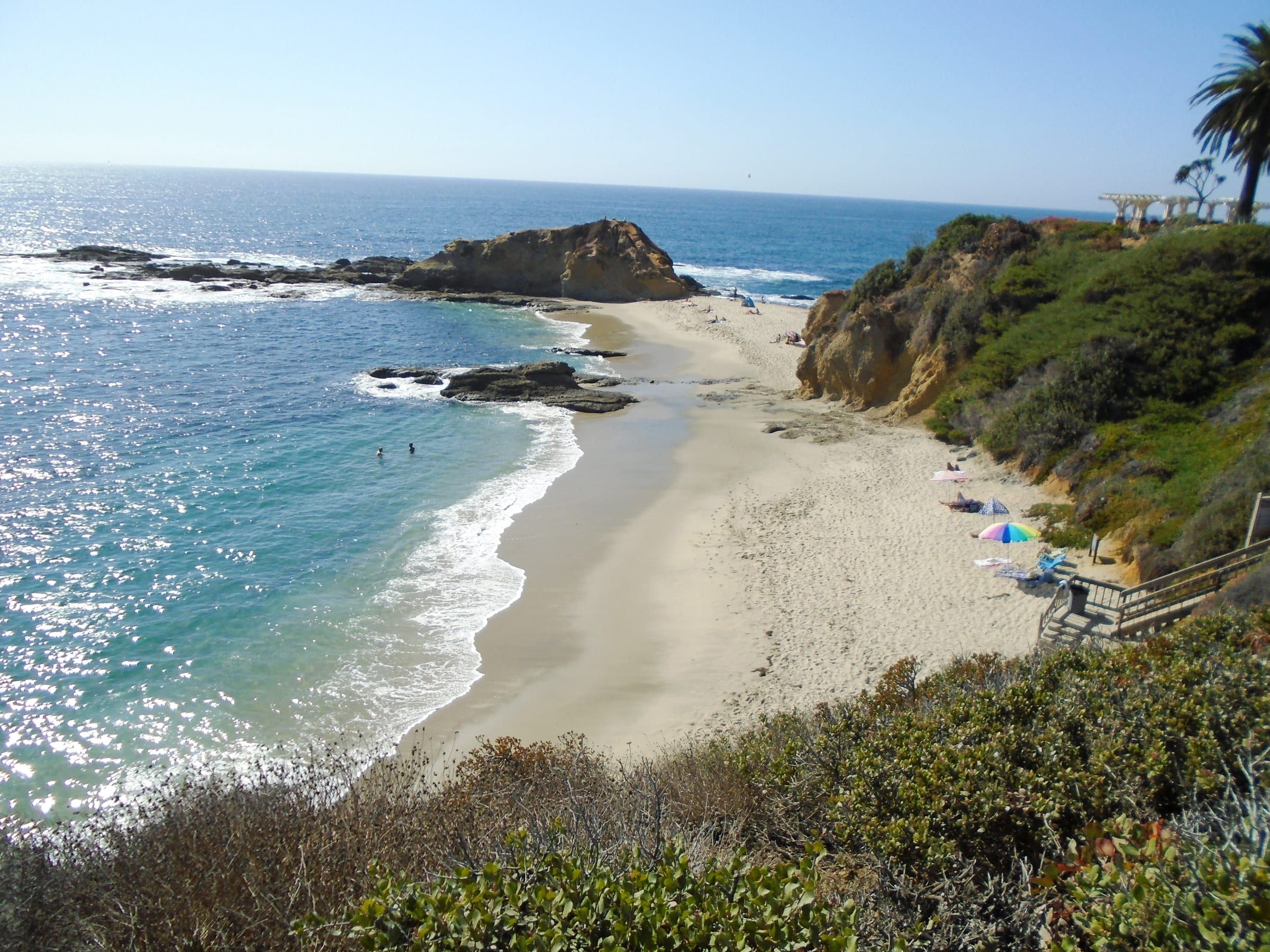
Totuava is a cove in South Laguna between Table Rock Beach and Thousand Steps Beach, and it has no public access point of its own.
What it’s like
Totuava is a cove on the South Laguna shore. Swim Guide describes it as a hard-to-find beach north of Thousand Steps Beach and connected to it. Table Rock Beach lies to the north, and Thousand Steps Beach lies to the south.
A 1985 Orange County environmental filing, titled Totuava Bay (5th Street) Beach Access, covered a five-foot easement from Pacific Coast Highway to a bluff stairway and the reconstruction of that stairway down to the bay. The filing does not say whether the work was done, and the Coastal Commission’s current access guide lists no stairway or access point at Totuava.
Getting there and parking
Totuava has no public access point of its own. The Coastal Commission’s file lists Table Rock Beach and Thousand Steps Beach and nothing between them. Swim Guide says you must use the Thousand Steps access point, and a 2021 Patch beach guide says there is no public access to Totuava itself.
Both guides send you through Thousand Steps Beach. Swim Guide says that once you step onto the sand from the Thousand Steps stairs, Totuava is the stretch to your right, to the north. Patch’s reporter timed a visit to a very low tide to see a sea cave at Thousand Steps and reach Totuava beyond it, and warned that you may become trapped if you do not watch the tide. Heed that warning. A cove with no public access point leaves you the same route out, and the tide decides how long that route stays open. Respect posted private property signs on the bluff and along the sand.
Parking follows Thousand Steps. The Coastal Commission lists on-street parking and restrooms there, and a 2021 Patch visit found unmetered spaces on the northbound side of Coast Highway early in the day. Thousand Steps closes between 9:00 p.m. and 6:00 a.m.
Rules and safety
Totuava sits near the line where two protected areas meet. California Fish and Wildlife describes the Laguna Beach State Marine Conservation Area as running from Goff Island south to Table Rock, and the Dana Point State Marine Conservation Area begins at the same latitude, 33 degrees 30.050 minutes north. OpenStreetMap places 5th Avenue, the cross street in the 1985 filing, just north of that latitude, while Swim Guide’s map point for Totuava sits south of it. These sources do not settle which area covers each rock.
The two areas differ, but both protect the pools. In the Laguna Beach area it is unlawful to injure, damage, take or possess any living, geological or cultural marine resource. The Dana Point area starts from the same rule but allows recreational take of finfish by hook-and-line or spearfishing, and lobster and urchin, which Laguna Beach does not. It also prohibits taking living marine resources from tide pools. Because the line runs close by, take nothing and check the posted signs and California Fish and Wildlife’s map before you fish.
Swim Guide notes a three-day rain advisory after each storm, because bacteria levels can rise. The Department of Marine Safety answers questions about tides and surf. Check the tide table before you start toward the cove, and leave the beach well before the tide returns.
Good to know
The 1985 filing describes a stairway, but the Coastal Commission’s file lists no access at Totuava today, so do not plan a visit around one. Our map pin for this cove is approximate.
Live from NOAA
Tides and water at Totuava
| Day | High and low tides |
|---|---|
| Loading NOAA predictions… | |
Sources: NOAA tide predictions, station 9410580 and NOAA NDBC buoy 46253 (owned by Scripps). The buoy reads open water offshore; water at the beach can differ. Check posted lifeguard flags before you swim.
Things to do
Things to do at Totuava
Living nearby
South Laguna, by the numbers
The closest neighborhood to Totuava Beach. Read the South Laguna guide.
CRMLS: homes for sale today; closed sales in the 12 months through October 19, 2026. A median needs 5 sales.
Questions
Is Totuava Beach public?
It has no public access point of its own. The Coastal Commission's access guide lists none there, and Swim Guide and Patch both say the cove has no public access of its own.
Where is Totuava Beach?
In South Laguna, between Table Rock Beach to the north and Thousand Steps Beach to the south. A 1985 county filing places the Totuava Bay access at 5th Street and Pacific Coast Highway.
Can you walk to Totuava from Thousand Steps?
Swim Guide says to use the Thousand Steps access. A 2021 Patch story reached Totuava from Thousand Steps at low tide and warned that you may become trapped if you do not watch the tide. The Department of Marine Safety answers questions about tides and surf.
Can you fish or collect at Totuava?
Take nothing from the tide pools or the rocks. The cove sits near the line between two conservation areas with different fishing rules, so check California Fish and Wildlife's map and the posted signs first.
Moving to Laguna Beach?
Get the printable moving checklist by email: what to do before you move, moving week and your first 30 days.
Last reviewed
Sources (8)
- A 1985 Orange County negative declaration titled Totuava Bay (5th Street) Beach Access, at 5th St and Hwy 1 in South Laguna, covered a five-foot easement from Pacific Coast Highway to a bluff stairway and reconstruction of the stairway to Totuava Bay; the page does not say whether the work was completed: ceqanet.lci.ca.gov, checked 2026-10-09
- Swim Guide: Totuava is a well-hidden beach north of Thousand Steps Beach and directly connected to it, with no public access of its own; the Thousand Steps access must be used, and once off the access point the right side is Totuava and the left side Thousand Steps; its map point sits at 33.4983, -117.7419; a 3-day rain advisory follows each storm because bacteria levels can rise: theswimguide.org, checked 2026-10-09
- Patch, Aug. 1, 2021: the reporter timed a visit to a steep low tide to see a cave at Thousand Steps and reach Totuava beyond it (the story places a cave at the north end in this passage and at the extreme south end in another, so this site gives no end); there is no public access to Totuava, so be mindful of the tides or you may become trapped; Thousand Steps has unmetered street parking on the northbound side of Coast Highway early in the day: patch.com, checked 2026-10-28
- The access file lists Table Rock Beach and Thousand Steps Beach (coordinates and stairs) and has no entry for Totuava; the map pin sits midway between the two listed points: api.coastal.ca.gov, checked 2026-10-09
- OpenStreetMap places 5th Avenue in South Laguna, the cross street in the 1985 filing, at about 33.501 N, just north of 33 degrees 30.050 minutes (33.5008 N): nominatim.openstreetmap.org, checked 2026-10-09
- Laguna Beach State Marine Conservation Area runs from Goff Island south to Table Rock with a south boundary at 33 degrees 30.050 minutes north; it is unlawful to injure, damage, take or possess any living, geological or cultural marine resource; fishing is not allowed: wildlife.ca.gov, checked 2026-10-09
- Dana Point State Marine Conservation Area: northern border abuts the Laguna Beach area at 33 degrees 30.050 minutes north; it is unlawful to injure, damage, take or possess any living, geological or cultural marine resource except as listed; take of living marine resources from tide pools is prohibited; recreational take of finfish by hook-and-line or spearfishing, and lobster and urchin, is allowed; Thousand Steps is named as a dive and snorkel spot: wildlife.ca.gov, checked 2026-10-09
- Thousand Steps Beach closes between 9:00 p.m. and 6:00 a.m.; the Department of Marine Safety is the contact for tides and surf: visitlagunabeach.com, checked 2026-10-09